So, Timothy reports that it's -18 F in Iowa. It's cold here, high today struggled for a while toward 10, but gave up at about 7 degrees around 3 p.m. Now it's 6, feels like -6 with the wind chill, and snow showers may drop a couple of inches on top of the three or four that are already on the ground. Just north of me, about 60 miles or so, however, in Erie, they're still getting snow on top of the 60 inches or so that fell on Christmas Day. I drove through a blinding lake-effect snow between Buffalo and Erie on Deember 8, when about 15-18 inches fell in about 8 hours, and what should have been a little over an hour's drive took almost four. I can't even imagine what 60 inches coming down looked like, and they've had another 10-15 since then, whenever the lake effect machine cranks up. We're at the southern edge of that snow belt, and we can get some pretty heavy snows, but not like that. So much for global warming....
Except that heavy, record lake effect snows are a sign of global warming. The heavy snow in the Great Lakes area ends around early or mid-January, most of the time, when the ice cover gets to its greatest extent. Erie and Ontario freeze over, and so there's no moisture to pick up when the cold Canadian air comes across the lake. As long as the water is warm, though, the snow machine forms. And so, what we are seeing now is record lake-effect snow long after the time that it should be shut off and the lakes frozen over. But Lake Erie hasn't frozen over completely for going on three winters now. So Erie, PA sees a 60 inch Christmas Day snow, a record for 24 hours, and the lake has a long way to go before it freezes over.
https://weather.com/science/environment ... er-weather
And if you want to read about the effects of global warming in the places where warm temperatures are the main attraction of the local geography, here's some additional information.
http://tucson.com/news/weather/tucson-s ... e-featured
Cold Snap
Moderator: Jon Estes
38 posts
• Page 1 of 2 • 1, 2
Re: Cold Snap
![]() by William Thornton » Mon Jan 01, 2018 6:12 pm
by William Thornton » Mon Jan 01, 2018 6:12 pm
Written as if by a true GW believer. Church is in session for 2018.
My stray thoughts on SBC stuff may be found at my blog,
-

William Thornton - Site Admin
- Posts: 12613
- Joined: Thu Aug 12, 2004 9:30 pm
- Location: Atlanta
Re: Cold Snap
![]() by Tim Bonney » Mon Jan 01, 2018 7:12 pm
by Tim Bonney » Mon Jan 01, 2018 7:12 pm
I’m not going to chase the global climate rabbit. But yep, it is darn cold up here right now. But Iowans just go on. We attended a brunch this morning at 9:30a with some church members while it was still below -15. It is cold up here often enough that if we don’t just get on with it, we’d never leave our houses. 
-

Tim Bonney - Site Admin
- Posts: 6571
- Joined: Wed Sep 28, 2011 9:17 am
- Location: Indianola, Iowa
Re: Cold Snap
![]() by Sandy » Mon Jan 01, 2018 10:18 pm
by Sandy » Mon Jan 01, 2018 10:18 pm
We are getting to the point, after eight years, where the cold and snow don't bother us much. On December 8, while coming home from Buffalo, I drove through about 50 miles of a lake effect blizzard between Angola, NY and Erie, PA at almost zero visibility and at less than 20 mph most of the way. Eight years ago, I'd have found a hotel and stopped.
I just thought it was interesting that while we're seeing this massive, lake effect snowfall caused by a warmer than normal Lake Erie, due to mild winters and warmer than normal summers, in my hometown in Arizona, they're talking about the average temperatures being significantly higher than normal over the same period of time, with a much different effect. In Arizona, it was dry conditions, and unusually large and widespread wildfires, while here, it's lake effect snow. You can draw your own conclusions, there are two articles there, based on scientific measurement, that explain why.
I just thought it was interesting that while we're seeing this massive, lake effect snowfall caused by a warmer than normal Lake Erie, due to mild winters and warmer than normal summers, in my hometown in Arizona, they're talking about the average temperatures being significantly higher than normal over the same period of time, with a much different effect. In Arizona, it was dry conditions, and unusually large and widespread wildfires, while here, it's lake effect snow. You can draw your own conclusions, there are two articles there, based on scientific measurement, that explain why.
- Sandy
Re: Cold Snap
![]() by Haruo » Mon Jan 01, 2018 11:52 pm
by Haruo » Mon Jan 01, 2018 11:52 pm
Yeah, it seems pretty clear that global warming (which can eventuate in local snowstorms) is reality. I'm still not at all sure to what extent it's human-carbon-release driven, though certainly to some extent, and I'm not sure what the best response is, how best to deal with it.
Haruo = Leland Bryant Ross
—
—
—
—
-

Haruo - Site Admin
- Posts: 13131
- Joined: Sat Aug 14, 2004 7:21 pm
- Location: Seattle
Re: Cold Snap
![]() by KeithE » Tue Jan 02, 2018 11:01 am
by KeithE » Tue Jan 02, 2018 11:01 am
All this talk about GLOBAL Warming with what is happening in Tucson or Western NY is pure nonsense.
The last three years have been the hottest GLOBALLY by all measurements.
Surface thermometer measurements:
Scroll to bottom and look under the D-N (Dec-Nov).
Since the Industrial Revolution the GLOBAL temperature has risen over 1.2C = 2.16F.
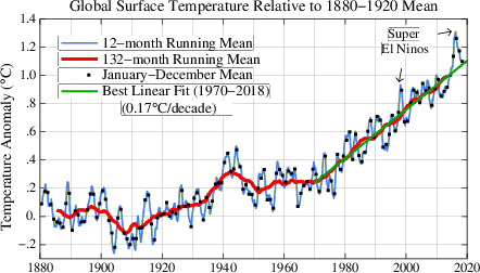
When the Dec 2017 measurements are analyzed the 2017 dot will appear well above the “Best Linear Fit (1970-2017)”.
Lower Tropospheric Satellite Based Measurements :


Human Caused GW
Even “skeptic” John Christy who spoke to our Science and Religion Lecture Series at the Discovery Center says the growth in human CO2/ghgs emissions and deforestation are contributing to global warming. He just doesn’t think this rise will amount to bad consequences and was adamantly against any regulation on our “proven” capitalistic system.
Much more to say but I’ll spare you.
The last three years have been the hottest GLOBALLY by all measurements.
Surface thermometer measurements:
Scroll to bottom and look under the D-N (Dec-Nov).
Since the Industrial Revolution the GLOBAL temperature has risen over 1.2C = 2.16F.
When the Dec 2017 measurements are analyzed the 2017 dot will appear well above the “Best Linear Fit (1970-2017)”.
Lower Tropospheric Satellite Based Measurements :
Human Caused GW
Even “skeptic” John Christy who spoke to our Science and Religion Lecture Series at the Discovery Center says the growth in human CO2/ghgs emissions and deforestation are contributing to global warming. He just doesn’t think this rise will amount to bad consequences and was adamantly against any regulation on our “proven” capitalistic system.
Much more to say but I’ll spare you.
Informed by Data.
Driven by the SPIRIT and JESUS’s Example.
Promoting the Kingdom of GOD on Earth.
Driven by the SPIRIT and JESUS’s Example.
Promoting the Kingdom of GOD on Earth.
-

KeithE - Site Admin
- Posts: 9362
- Joined: Thu Aug 12, 2004 8:02 pm
- Location: Huntsville, AL
Re: Cold Snap
![]() by Tim Bonney » Tue Jan 02, 2018 11:33 am
by Tim Bonney » Tue Jan 02, 2018 11:33 am
I agree with I your completely Keith. I just know that no one here seems to change their mind.
-
Tim Bonney - Site Admin
- Posts: 6571
- Joined: Wed Sep 28, 2011 9:17 am
- Location: Indianola, Iowa
Re: Cold Snap
![]() by KeithE » Tue Jan 02, 2018 6:32 pm
by KeithE » Tue Jan 02, 2018 6:32 pm
Informed by Data.
Driven by the SPIRIT and JESUS’s Example.
Promoting the Kingdom of GOD on Earth.
Driven by the SPIRIT and JESUS’s Example.
Promoting the Kingdom of GOD on Earth.
-
KeithE - Site Admin
- Posts: 9362
- Joined: Thu Aug 12, 2004 8:02 pm
- Location: Huntsville, AL
Re: Cold Snap
![]() by Tim Bonney » Tue Jan 02, 2018 7:43 pm
by Tim Bonney » Tue Jan 02, 2018 7:43 pm
-
Tim Bonney - Site Admin
- Posts: 6571
- Joined: Wed Sep 28, 2011 9:17 am
- Location: Indianola, Iowa
Re: Cold Snap
![]() by Dave Roberts » Thu Jan 04, 2018 9:53 am
by Dave Roberts » Thu Jan 04, 2018 9:53 am
My favorite cold snap quote: "It's so cold in Washington, politicians have actually been seen with their hands in their own pockets."
"God will never be less than He is and does not need to be more" (John Koessler)
My blog: http://emporiadave.wordpress.com/
My blog: http://emporiadave.wordpress.com/
-

Dave Roberts - Site Admin
- Posts: 7714
- Joined: Thu Aug 12, 2004 1:01 pm
- Location: Southside, VA
Re: Cold Snap
![]() by Rvaughn » Thu Jan 04, 2018 12:25 pm
by Rvaughn » Thu Jan 04, 2018 12:25 pm
Now that's funny -- though perhaps a bit too optimistic!
-

Rvaughn - Posts: 1332
- Joined: Sun Feb 11, 2007 4:54 pm
- Location: East Texas
Re: Cold Snap
![]() by Jim » Fri Jan 05, 2018 10:27 am
by Jim » Fri Jan 05, 2018 10:27 am
- Jim
- Posts: 3773
- Joined: Sun Jan 08, 2006 2:44 pm
- Location: Lexington, Ky.

Re: Cold Snap
![]() by Rvaughn » Sun Jan 07, 2018 10:17 pm
by Rvaughn » Sun Jan 07, 2018 10:17 pm
-
Rvaughn - Posts: 1332
- Joined: Sun Feb 11, 2007 4:54 pm
- Location: East Texas
Re: Cold Snap
![]() by Dave Roberts » Mon Jan 08, 2018 10:00 am
by Dave Roberts » Mon Jan 08, 2018 10:00 am
I try to stay out of the "climate change" debate here, because I know it goes nowhere, but this is worth a read. I received it this morning from Don Garber, a friend who has spent his life working for NASA at the Langley Research Facility. He related this as some of the most recent studies in oceanography. The losses of oxygen are serious.
"God will never be less than He is and does not need to be more" (John Koessler)
My blog: http://emporiadave.wordpress.com/
My blog: http://emporiadave.wordpress.com/
-
Dave Roberts - Site Admin
- Posts: 7714
- Joined: Thu Aug 12, 2004 1:01 pm
- Location: Southside, VA
Re: Cold Snap
![]() by Haruo » Mon Jan 08, 2018 2:21 pm
by Haruo » Mon Jan 08, 2018 2:21 pm
How is oceanic oxygen related to / intertwined with atmospheric oxygen? Now there's a good question to pose to a bunch of random Baptists.
Haruo = Leland Bryant Ross
—
—
—
—
-
Haruo - Site Admin
- Posts: 13131
- Joined: Sat Aug 14, 2004 7:21 pm
- Location: Seattle
Re: Cold Snap
![]() by Tim Bonney » Mon Jan 08, 2018 3:08 pm
by Tim Bonney » Mon Jan 08, 2018 3:08 pm
-
Tim Bonney - Site Admin
- Posts: 6571
- Joined: Wed Sep 28, 2011 9:17 am
- Location: Indianola, Iowa
Re: Cold Snap
![]() by KeithE » Mon Jan 08, 2018 5:04 pm
by KeithE » Mon Jan 08, 2018 5:04 pm
Informed by Data.
Driven by the SPIRIT and JESUS’s Example.
Promoting the Kingdom of GOD on Earth.
Driven by the SPIRIT and JESUS’s Example.
Promoting the Kingdom of GOD on Earth.
-
KeithE - Site Admin
- Posts: 9362
- Joined: Thu Aug 12, 2004 8:02 pm
- Location: Huntsville, AL
Re: Cold Snap
![]() by Dave Roberts » Tue Jan 09, 2018 8:47 am
by Dave Roberts » Tue Jan 09, 2018 8:47 am
"God will never be less than He is and does not need to be more" (John Koessler)
My blog: http://emporiadave.wordpress.com/
My blog: http://emporiadave.wordpress.com/
-
Dave Roberts - Site Admin
- Posts: 7714
- Joined: Thu Aug 12, 2004 1:01 pm
- Location: Southside, VA
Re: Cold Snap
![]() by Jim » Tue Jan 09, 2018 2:21 pm
by Jim » Tue Jan 09, 2018 2:21 pm
- Jim
- Posts: 3773
- Joined: Sun Jan 08, 2006 2:44 pm
- Location: Lexington, Ky.
Re: Cold Snap
![]() by KeithE » Wed Jan 10, 2018 11:35 am
by KeithE » Wed Jan 10, 2018 11:35 am
Informed by Data.
Driven by the SPIRIT and JESUS’s Example.
Promoting the Kingdom of GOD on Earth.
Driven by the SPIRIT and JESUS’s Example.
Promoting the Kingdom of GOD on Earth.
-
KeithE - Site Admin
- Posts: 9362
- Joined: Thu Aug 12, 2004 8:02 pm
- Location: Huntsville, AL
Re: Cold Snap
![]() by Tim Bonney » Wed Jan 10, 2018 12:25 pm
by Tim Bonney » Wed Jan 10, 2018 12:25 pm
I've avoided these climate topics because, basically, I agree with Keith's analysis every time I've looked at it.
But even given that, what makes the anti-climate change side so anti-climate change? None of the steps that those who see climate change as important if taken would hurt the earth yet if the 97% are right, we are really in trouble if we don't make changes.
I don't see the downside in reducing emissions, etc. Many of them would make our world better (less pollution etc. ) even if you don't believe in climate change.
-
Tim Bonney - Site Admin
- Posts: 6571
- Joined: Wed Sep 28, 2011 9:17 am
- Location: Indianola, Iowa
38 posts
• Page 1 of 2 • 1, 2
Return to Politics and Public Policy Issues
Who is online
Users browsing this forum: No registered users and 4 guests